In the Philippine mountaineering community, there is a notorious concept known as the budol climb. It usually starts with a friend messaging you: “Let’s hike this weekend! It’s just a minor climb, rated 4/9. We’ll be down by lunch.” For thousands of unsuspecting beginners, that budol happens at Mt. Daraitan.
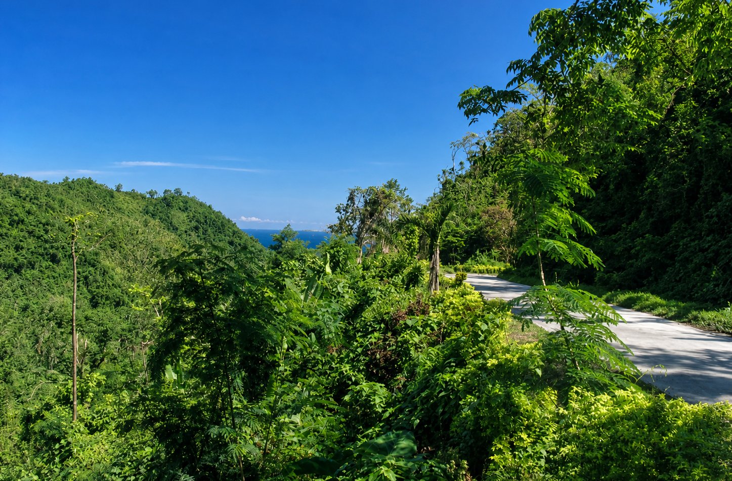
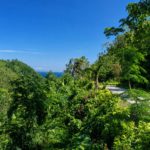
Sitting on the windward edge of the Sierra Madre range in Tanay, Rizal, Mt. Daraitan has built a reputation that heavily contradicts its paper specifications. While its elevation peaks at a modest 739 Meters Above Sea Level (MASL), the reality on the ground is entirely different. This is not a rolling grassy hill. This is a tropical karst environment—a jagged, vertical coral reef lifted from an ancient ocean, covered in a suffocating canopy of dipterocarp forest.
If you are planning to conquer Mt. Daraitan this 2025 season, you need to abandon the idea that “minor” means “easy.” This guide strips away the filtered social media aesthetics to give you the gritty, technical reality of what it takes to survive the limestone crags and river rapids of Tanay’s most punishing day hike.
The Anatomy of the Climb: Hard Stats
-
Target: Mt. Daraitan & Tinipak River Traverse
-
Elevation: 739+ MASL
-
Difficulty: 4/9 (Pinoy Mountaineer System)
-
Trail Class: 1-4 (Requires technical 3-point scrambling)
-
Duration: 3 to 4 hours ascent; 2 hours descent (Traverse)
-
Distance: Roughly 8-9 kilometers (Full Loop/Traverse)
The Physical Toll: How to Actually Prepare
Do not use Mt. Daraitan as your warm-up mountain. If you have spent the last six months sitting at a desk, the gradient of this trail will physically break you before you even reach the halfway mark.
Because Mt. Daraitan lacks long, flat ridges for active recovery, your cardiovascular system will be pinned in Zone 3 or Zone 4 for hours. Your calves will burn with lactic acid within the first forty-five minutes. Furthermore, the upper “Rock Garden” requires upper body strength. You will be pulling your own body weight over limestone boulders.
To prepare for the specific demands of the Mt. Daraitan trail, standard jogging is not enough. You need to focus on eccentric leg strength and stair climbing. Load a backpack with 5 kilograms of water and hit the stairmaster, or do high-volume lunges and squats.
The Beta: Train your grip. The limestone is abrasive, and your forearms will fatigue quickly from holding onto the rock faces. Incorporate dead hangs or farmer’s walks into your gym routine two weeks prior to the climb.
The Two Faces of the Mountain: Amihan vs. Habagat
Climbing Mt. Daraitan in April is a completely different expedition than climbing it in August. The mountain has a severe split personality dictated by the Philippine monsoon seasons.
The Amihan (Dry Season – November to May): During these months, the trail is a suffocating dust bowl. The loamy soil turns to powder, and every hiker ahead of you kicks up a cloud of dirt that coats your lungs and your gear. However, the dry limestone provides maximum mechanical friction, allowing for faster, safer rock scrambling. This is also the prime window to witness the famous “Sea of Clouds” at the summit, as the cold night air condenses the humidity coming off the Tinipak River below.
The Habagat (Wet Season – June to October): When the monsoon rains hit, Mt. Daraitan transforms into a hostile, slippery trench. The dust turns into a viscous, chocolate-mousse clay that adheres to your boots, adding two pounds to every step. The jagged rocks become slick with mud and wet moss, turning a simple scramble into a high-stakes balancing act. Traverse times often double during the Habagat.
Safety Check: Limatik Warning. During the wet months, the mossy sections of the Mt. Daraitan forest harbor Haemadipsa (blood leeches). They track your heat and vibration. Wear leggings or high socks, and never forcefully pull a feeding leech off your skin, as the jaws will remain and cause a festering infection. Salt them or flick them off.
The Beta: Always check the localized weather via the Tanay Tourism Facebook page before your trip. If a low-pressure area (LPA) is hitting the Quezon/Rizal border, cancel the climb. A wet trail is miserable, but a flooded river canyon is lethal.
The Geology of Pain: Understanding Tropical Karst
To survive Mt. Daraitan, you must understand the ground you are walking on. Unlike the volcanic ash of Mt. Makiling, the bedrock here is solid limestone. Locals call these jagged rock formations marmol (marble).
This geology creates two immediate, brutal realities. First, the rock is razor-sharp. You will be forced to use your hands to haul your body weight over serrated ridges. A slip here does not result in a muddy bruise; it results in a laceration.
Second, limestone is porous. Rainwater percolates straight through the surface, creating an arid environment above the river line.
Safety Check: Dehydration Risk. Many hikers underestimate the water requirement on Mt. Daraitan because they assume they can refill at a jungle spring. You cannot. You must carry a minimum of 2 to 3 liters of water from the jump-off to survive the midday heat at the summit.
The Beta: Do not drink all your water on the ascent. The descent is incredibly taxing, and running dry while navigating technical limestone under the 11:00 AM sun causes severe heat exhaustion and muscle cramping. Pack oral rehydration salts (ORS).
The Ascent: An Unforgiving “Unli-Ahon”
The assault begins almost immediately after you leave the Barangay Daraitan jump-off. The initial approach takes you through farmland, but once you enter the forest line, the gradient kicks up aggressively. It is an unli-ahon—a continuous, relentless upward grind.
In the lower third of the mountain, massive root systems act as natural staircases. These roots are heavily polished by thousands of boots and are coated in a slick layer of moss.
By the time you reach Station 2, the soil thins out, and the marmol takes over. Your trekking poles become a liability here because they can snap inside rock crevices. Stow them on your pack and engage your upper body. Maintain three points of contact at all times.
At 739 MASL, the summit clearing of Mt. Daraitan offers a panoramic vantage point of the Sierra Madre. There is no canopy cover. If you arrive by 11:00 AM, you will be roasted by high-index UV radiation bouncing off the white limestone.
The Beta: Bring heavily rubber-dipped industrial gloves. Do not bring expensive fleece liners or cheap cotton gloves. The sharp limestone of the Mt. Daraitan summit approach will shred cotton in minutes. You need construction-grade friction.
The Midnight Protocol: 2025 Day Hike Itinerary
To beat the crowds and the heat, the standard Mt. Daraitan day hike is an “Alpine Start.” This requires extreme sleep deprivation but yields the best results.
-
01:00 AM: Depart Metro Manila. (A private van charter is strongly recommended to avoid the exhaustion of public commuting).
-
03:00 AM: Arrive at Brgy. Daraitan Hall. Submit your manifest, sign the waivers, and secure your local guides.
-
03:30 AM: Start Trek. Headlamps ON. The forest will be pitch black and humid. Establish a slow, sustainable pace to avoid premature burnout.
-
05:30 AM: Arrive at Station 3. First light breaks. The wind chill here will drastically drop your core temperature if your shirt is soaked in sweat.
-
06:00 AM: Summit Assault. Secure your spot at the limestone crags.
-
07:30 AM: Start Descent via the Traverse Trail. Do not linger too long; the sun hits the exposed rock hard by 8:00 AM.
-
10:00 AM: Arrive at Tinipak River. Rest and early lunch.
-
11:00 AM: Spelunking (Tinipak Cave) and cold river swimming.
-
13:00 PM: Trek back to the Jump-off (Flat dirt trail).
Safety Check: Noise Discipline. While trekking at 3:00 AM, keep your voices down. The mountain is home to nocturnal wildlife, and sound carries far in the valley. Silence your Bluetooth speakers. Leave No Trace applies to noise pollution as well.
The Beta: Try to sleep in the van on the way to Tanay. Starting a grueling vertical kilometer climb on zero sleep elevates your heart rate artificially and drastically impairs your balance on the technical rock sections.
The Traverse Descent: Destroying Your Knees
Getting to the top is only half the battle. The standard 2025 itinerary does not involve back-trailing; it demands a traverse down the opposite face of the mountain toward the Tinipak River.
The descent of Mt. Daraitan is notoriously steeper and wilder than the ascent. You are dropping nearly 600 meters of elevation in just a few kilometers. This puts massive eccentric loading on your quadriceps and patellar tendons. By the halfway mark, your legs will shake uncontrollably.
During the wet season, this trail becomes a high-angle mud chute. Standing upright is physically impossible due to the lack of friction. Hikers must resort to “butt-sliding” down the clay slopes, grabbing onto sturdy vines to control their momentum.
The Beta: Re-deploy your trekking poles for the descent. Using poles transfers the violent braking force from your knees to your shoulders and chest. If you have a history of Iliotibial Band (ITB) friction syndrome, proactively wrap your knees with athletic tape before you start the downward trek.
The Tinipak River System: Hydrological Hazards
After two hours of punishing descent, the dense jungle breaks, revealing the Tinipak River. It is a striking visual contrast: massive, bleached-white limestone boulders framing rushing, mineral-rich turquoise water. It is one of the most beautiful river systems in Rizal, but it commands absolute respect.
While the water may be crystal clear where you stand, the river canyon is narrow and acts as a massive funnel for rain falling miles away in the Kaliwa watershed.
Safety Check: Extreme Flash Flood Protocol. If you are swimming in the Tinipak River and notice the water suddenly turning turbid or “chocolate brown,” evacuate the riverbank immediately and scramble to high ground. This sediment rush is the leading indicator of a flash flood wave traveling down from General Nakar. You will only have minutes to react.
A short wade upstream brings you to the Tinipak Cave. Spelunking here involves wading through waist-deep, freezing water in absolute darkness. A reliable, waterproof headlamp is non-negotiable; a smartphone flashlight will not survive the humidity.
The Beta: Leave No Trace (LNT) is strictly enforced here. The Tinipak River is a direct water source for the indigenous Dumagat and the local barangay. Do not bathe with chemical soaps or shampoos in the river. Rinse the mud off with water, and save the full shower for the paid liguan (wash areas) back at the jump-off.
Gear That Actually Works (And What Will Fail)
Packing for Mt. Daraitan requires abandoning general hiking advice in favor of highly specific tactical choices for a “Hot, Wet, and Sharp” environment.
-
Footwear: Leave the heavy, waterproof Gore-Tex hiking boots at home. Once you cross the river or wade into the cave, water will flood over the collar of the boot and stay there, turning your footwear into heavy, waterlogged anchors. Wear deep-lug trail runners with mesh uppers. They drain instantly and provide superior agility when hopping across the marmol.
-
Clothing: “Cotton kills” in the Sierra Madre. The humidity means a cotton t-shirt will soak through with sweat in twenty minutes and remain wet for the rest of the day. Wear synthetic, moisture-wicking fabrics. Opt for long sleeves and tights to protect your skin from sharp rocks and rattan thorns on the Mt. Daraitan trail.
-
Illumination: A 200+ lumen headlamp. You need both hands free to scramble over the rocks, making handheld flashlights a dangerous liability.
Post-Climb Survival: The 2025 Administrative Reality
As the popularity of ecotourism surges, the local government unit of Tanay has clamped down on unregulated access. You must register at the Barangay Hall, submit a full hiker manifest, and sign a liability waiver. Strict daily carrying capacity quotas are now enforced. Attempting to show up without a prior booking on a weekend guarantees you will be turned away from the Mt. Daraitan jump-off.
Expect a DIY budget of around ₱1,200 to ₱1,500 per person if you are in a group of four. This covers the fragmented community fees: the mandatory local guide (strictly enforced 1:5 ratio), environmental levies, tricycle charters, and bridge crossing tolls.
Once you drag yourself back to the barangay hall, covered in limestone dust and dried sweat, pay the ₱20-₱50 fee to use the local liguan (shower area). It is a simple bucket-and-dipper system, but the freezing mountain water is the best feeling in the world after the grueling heat of the mountain.
The Beta: The cellular signal for digital wallets like GCash is completely nonexistent in the river valley. Break your cash into ₱20, ₱50, and ₱100 bills before leaving Metro Manila, as local stores rarely have change. Furthermore, do not skip the post-climb meal. Stop by Tanay Public Market or a roadside eatery for a steaming bowl of Bulalo (beef marrow soup). The salty broth is the ultimate electrolyte replacement.
The Final Verdict
Mt. Daraitan is the ultimate equalizer. It does not care about how expensive your gear is or how many flat, grassy hills you have walked before. It tests your grip strength, your joint stability, and your mental fortitude.
When you finally walk out of that barangay, bruised, exhausted, and carrying a bag of muddy clothes, you walk away with a genuine sense of accomplishment. You didn’t just walk up a hill; you survived the marmol.
Ready to plan your exact route? For more technical insights, gear reviews, and deep-dive guides into the Philippine mountains, keep exploring our outdoor journals.
Related posts:
 Beyond the Rolling Hills: Discovering the Wild Heart of Tuscany in Acquerino
 Brazilian Cachaça trip Day Two-Rio Grande do Sul: Casa Bucco and beyond
 Mt. Makiling Hiking Guide 2026: The New Rules, Limatiks, and the “Paved Agony”
 Kochi: Japan’s Wild Southern Coast That Most Tourists Never See
 Unveiling Athens: Best thing to do while there
Leave a Reply