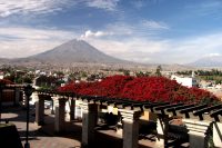
Banks are plentiful especially around the center of town and Plaza del Armas. Unlike most other cities, there are some banks in Arequipa that actually are open on Sundays! ATM machines are abundant in the center of town and are open 24/7. Taxi Drivers - in Arequipa do not use meters. You need to decide on a price before you get into the car. Typically trips around town will cost merely several soles. We used Alberto Loayza, a taxi driver … [Read more...]
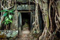
Angkor Wat, Cambodia
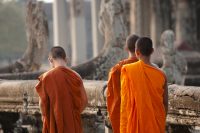
Angkor Wat is arguably one of the top man-made architectural destinations in the world. Over 100 temples form the entire complex. The main temples are surrounded by an imposing square moat which completely encircles the complex. The primary entrance is raised above the moat - pictures from this entrance are of the classic Angkor Wat pagodas that grace the covers of guide books. Rich in Khmer history, it is worth some time reading about this … [Read more...]
Angkor Wat, Cambodia – Land Mine Museum

Land Mines are still a huge problem in Cambodia. The main paved/dirt road from the Thai/Cambodia border town of Poipet is well marked with signs on both sides of the road indicating that it is very dangerous to walk off the road. Over 100 people each month in Cambodia are maimed or killed by stepping on unexploded land mines. The Land Mine Museum is well worth visiting - it is sobering, sad and educational at the same time. It is located not far … [Read more...]
Angkor Wat, Cambodia – More Information
Banks - There are several banks in Siem Reap with International ATM's throughout town. How things have changed in a few years! All the banks are located near the center of town most around the Old Market. Guides - The small free magazine called The Angkor Guide is published once every 6 months and is a must have for tourists. It is more up to date than most guidebooks and tourist publications and it is available at many of the guest homes … [Read more...]
Willow Steakhouse, Jamestown CA – January 2002

Willow Steakhouse Jamestown - When in the historic mining town of Jamestown, California be sure to swagger up to the bar at The Willow Steakhouse, Restaurant & Saloon located at corner of Willow & Main Street. This is an authentic looking western style (gold rush era feel) bar & restaurant with a rich history (be sure to read the history section on their menu). The building dates back to the early 1860's and was named for the willow trees growing … [Read more...]
Bangkok, Thailand – Attractions & Activities

Bangkok may not be for everyone. The high heat, humidity, congestion and air pollution may be too much to take for some people. There are so many attractions, including Wats, that a tourist could spend several weeks in Bangkok and still not see everything. It is hard to define the allure of Bangkok. At first glance it is a busy chaotic, polluted city - that is true; it is all of these things. However, once one delves into the history, attractions … [Read more...]
Bangkok, Thailand – Transportation
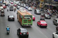
NOTE: Bangkok's two airports are highlighted first on this page. All other ground transportation is described below them in alphabetical order. Airports Taxis Metro (MRT) Rideshare BTS Skytrain Tuk Tuks Bicycle Walking BRT Longtail Buses Train Mini-Van Cycle Rickshaw Motorcycle Songthaew One word summarizes traveling via Bangkok roads - terrible! Drivers use the left hand side of the road - well, at … [Read more...]
Bangkok, Thailand – Food
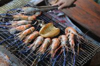
Thai food is incredible in it's flavors and diversity. Street vendors are everywhere in Bangkok. Depending where you are in this city, you can eat at most any hour of the day or night. Most of these food vendors setup shop on a street sidewalk - they have a small glass container for displaying the food, maybe a few plastic chairs/tables and they will have a small stall for cooking the actual food - which is done by using a stove hooked into a … [Read more...]
Bangkok, Thailand – More Information
Personal References We would like to thank the following four individuals for their insights and knowledge about Bangkok and Thailand in general: Nadia K. Nongnart P. Pattira Thitimajshima SoMa There are many resources available on the Internet about travel in Bangkok & Thailand in general. Here are just a few recommended ones. Thailand is our most visited country outside of the USA so when the latest version of a new Thailand … [Read more...]
Lamu, Kenya – Conclusion

The last visual scene I have of Lamu is on a dhow heading for Manda Island. I glanced back over the choppy waters at the small town concentrated along the waterfront. The coral white-washed buildings with their distinctive pillared round arches were a stark contrast to the dark water and clouds overhead. Leaving by boat leaves one with a sense of longing - a lingering sadness at leaving and not having spent enough time here. Small wooden dhows … [Read more...]
- « Previous Page
- 1
- …
- 139
- 140
- 141
- 142
- 143
- …
- 149
- Next Page »