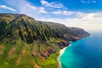
LIHUE, KAUAI - When rating the Hawaiian Islands, the readers of Travel + Leisure magazine have spoken and their number one choice is again the beautiful Garden Isle of Kauai. For the second consecutive year and third year out of the past five, Kauai has earned the distinction of being named Hawaii's Best Island in the 2010 World's Best Awards announced by Travel + Leisure. "This award is shared by all of the people of Kauai who love our … [Read more...]
Colca Canyon, Peru – July 2010

The Colca Canyon Peru is one of Peru's treasures - a canyon so deep that only one other canyon in the world is deeper, a place so little visited yet its only 5 hours from Arequipa, Peru's largest southern city. Hiking trips can be arranged from Arequipa. Typically you can hike to the bottom from the canyon's rim in several hours along trails that switchback down the sides. The bottom of the canyon has an almost Mediterranean feel. There are fig … [Read more...]
Back from LA

Just got back from the City of Angels. Had the Natural History museum exhibits all to myself - 1st Friday of every month open late, live bands setup shop and food - and some of the southlands pre-eminent professors and researchers give lectures, setup right among the exhibits. Def a highlight. Amazing gold and gem collection. World's largest known Ammonites. I felt like Ben Stiller in the Night of the Museum...well without the displays coming to … [Read more...]
Hitch Hiking through Jordan
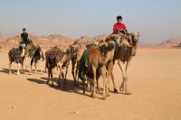
There is the Arabic world, the Western world, the Indian world, the Asian world and the African world. we are loving every minute of our time in the Arabic world. Greetings from Dead Sea high on top of Mt. Nebo overlooking Jerusalem City and Palestine Territory. Can see lights of this old city already popping out, about 15 clicks from where we are standing. We are near the John the Baptism site and at the Moses memorial. One … [Read more...]
Kuru Shoes
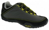
Kuru Shoes (Reviewed: Jun 2010)We recently wore a pair of these shoes on a trip to Hawaii. While being new these shoes hardly needed breaking in and wore wonderfully on hikes in the diverse microclimates of Maui. From running beachside on the edge of the surf to hiking at 10,000 feet on the upper slopes of Haleakala these shoes held up very well to the different rigors. Kuru shoes are lightweight, extremely comfortable, and very breathable … [Read more...]
Exploring the Diversity of Hawaii’s Big Island

We boarded the plane leaving for Kona behind a clean cut well-dressed businessman toting a RollAboard with a book tucked in tightly in the back. Only one word of the title showed, "sex" and this apparently caught the eye of a number of travelers as we heard hints of conversation and chuckles from behind us. But no one had the guts to actually ask this traveler for more details, juicy or otherwise. For those who know me, know the serious … [Read more...]
Moon Take a Hike Washington DC

Moon Take a Hike Washington DC by Theresa Dowell Perhaps you don't normally associate Washington DC with hiking but the DC area offers some killer hiking opportunities ranging from historic grounds to mountains to beaches and waterfalls. This latest Moon Handbook spotlights 80 hikes in Washington DC and eastern Maryland (all of them completed by the author). This book highlights some of DC's top trails by category. Examples include best bird … [Read more...]
Moon Take a Hike Portland

Moon Take a Hike Portland by Barbara I. Bond This latest Moon Handbook spotlights Portland as an "outdoor" city - with over 37,000 square feet of open space. What better way to explore all this than by hiking. This book highlights some of Portland's top trails by category. Examples include best bird watching, best "butt kickers", hikes with children, "peak baggers" , waterfalls, wildflowers and best views. The trails are organized by … [Read more...]
The Great Wall and the Great Market
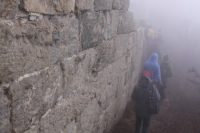
My toes are numb, I'm not sure I even have toes anymore. We have elected to take a tour to "the secret wall" somewhere along China's nearly 4000 mile "Great Wall". This is in the dead of mid April, Spring in many parts of the northern Hemisphere, but here winter's icy tentacles are far reaching and we are bundled up in multiple layers of clothing. We are all huddled in an old van for 3 hours to this "secret spot". The dense, grey gloomy fog of … [Read more...]
Yosemite, Sequoia & King’s Canyon

Yosemite, Sequoia & King's Canyon by Lonely Planet Three extremely popular California located National Parks are covered in one book. Yosemite has all the name recognition but Sequoia & Kings Canyon also have superb outdoor beauty. The focus of the National park series is outdoor activities and Lonely Planet does not disappoint with their detailed itineraries, hiking options, adventure options, and family friendly trips. … [Read more...]
- « Previous Page
- 1
- …
- 54
- 55
- 56
- 57
- 58
- …
- 71
- Next Page »