Warm-weather travel often gets reduced to beaches and resort photos, even though the places people remember most usually have much more going on around them. Some destinations are defined by colonial architecture and busy waterfront districts, while others revolve around highways, ferry crossings, marinas, or neighbourhoods beyond the main tourist areas.
Even within the Caribbean, nearby islands can feel completely different once travellers move past the coastline. Geography, architecture, and local movement patterns often shape the experience just as much as the weather itself. The destinations below highlight how climate, local character, and regional connections influence the way travellers experience a place.
Key Attractions and Geographical Layout of Orlando
Orlando is much larger than many first-time visitors expect. Interstate 4 runs through the centre of the metro area, linking the tourism district near International Drive with Downtown Orlando and the suburbs farther east.
Around Lake Eola, office towers, apartment buildings, and walking paths give the city centre a noticeably different atmosphere from the theme park corridors near Lake Buena Vista. Sand Lake Road also stays busy well into the evening, particularly around the shopping plazas, restaurants, and entertainment complexes south of Universal Boulevard.
The tourism zone around Kissimmee and Davenport has expanded over the last decade, especially as many families are opting for the best Orlando vacation rentals near Walt Disney World, Flamingo Crossings, and the western entrance routes near US-192. Gated villa communities around ChampionsGate and Reunion sit within driving distance of the parks while also giving access to golf courses, grocery stores, and residential areas that feel less crowded than the hotel strips near International Drive.
Many visitors stay focused on the major parks, though smaller locations around Central Florida are worth the drive. Winter Park has brick streets lined with older buildings near Park Avenue, plus boat tours passing through narrow canals connecting the local lakes. East of downtown, neighbourhoods around Mills 50 and Colonial Drive show a completely different side of the city with Asian supermarkets, older motels, and long-running local businesses.
Historical Architecture and Landmarks of Old San Juan
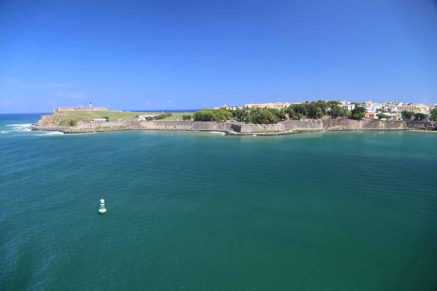
Old San Juan sits on a small island connected to mainland Puerto Rico by bridges crossing San Antonio Channel. The historic district still follows the original Spanish colonial street grid, with steep blue cobblestone roads climbing uphill toward forts and plazas. Calle de la Fortaleza remains one of the busiest streets in the district, especially near Plaza de Armas, where locals gather beneath shaded benches during the afternoon heat.
Castillo San Felipe del Morro dominates the northwestern edge of the city beside the Atlantic Ocean. Thick stone walls surround open grassy fields where families fly kites on windy days. Further east, Castillo San Cristóbal stretches across a large section of the old defensive perimeter with tunnels, lookout points, and elevated terraces facing the harbour.
Smaller details around the district tend to stay memorable. Balconies covered in plants hang above narrow alleyways near Calle del Cristo. Vendors around Plaza Colón sell piraguas and souvenirs beside old statues and fountains.
Near the waterfront promenade, cargo ships still pass through San Juan Bay while fishing boats move around the marina. Even with the presence of tourists, Old San Juan continues to function as an active neighbourhood with schools, churches, apartments, and government buildings.
Navigation and Transit Routes Between Caribbean Islands
Travel between Caribbean islands is shaped heavily by geography. Some islands sit close enough together for regular ferry connections, while others rely on short regional flights because of the wider stretches of open sea between them.
In the Eastern Caribbean, ferries regularly carry passengers between Saint Martin, Anguilla, Saint Barthélemy, and nearby ports in the British Virgin Islands. Harbours become active early in the morning as travellers line up beside cargo shipments, fishing boats, and charter catamarans preparing to leave the docks.
Cruise traffic also shapes how many travellers experience the region. A great luxury Caribbean cruise often includes stops across multiple islands, connecting places like St Thomas, Barbados, Antigua, and Curaçao through large regional ports. Around Philipsburg in Sint Maarten, cruise terminals sit directly beside shopping streets and waterfront boardwalks filled with excursion groups during docking hours. Bridgetown and San Juan function similarly, with terminals located close to historic districts and transport hubs.
Regional airports handle much of the shorter-distance travel. Smaller aircraft regularly operate routes between islands where ferries would take several hours or become unreliable during rough weather. At airports like Grantley Adams International in Barbados or Queen Beatrix International in Aruba, departure boards often list neighbouring islands alongside North American and European flights.
Geography and Climate Conditions of Aruba
Aruba’s landscape surprises travellers expecting dense tropical vegetation. Much of the island stays dry throughout the year, with cactus fields, rocky hills, and low divi-divi trees shaped by constant trade winds. The northern coastline near Arikok National Park looks especially rugged, with rough surf crashing against limestone formations and narrow dirt roads leading toward isolated viewpoints.
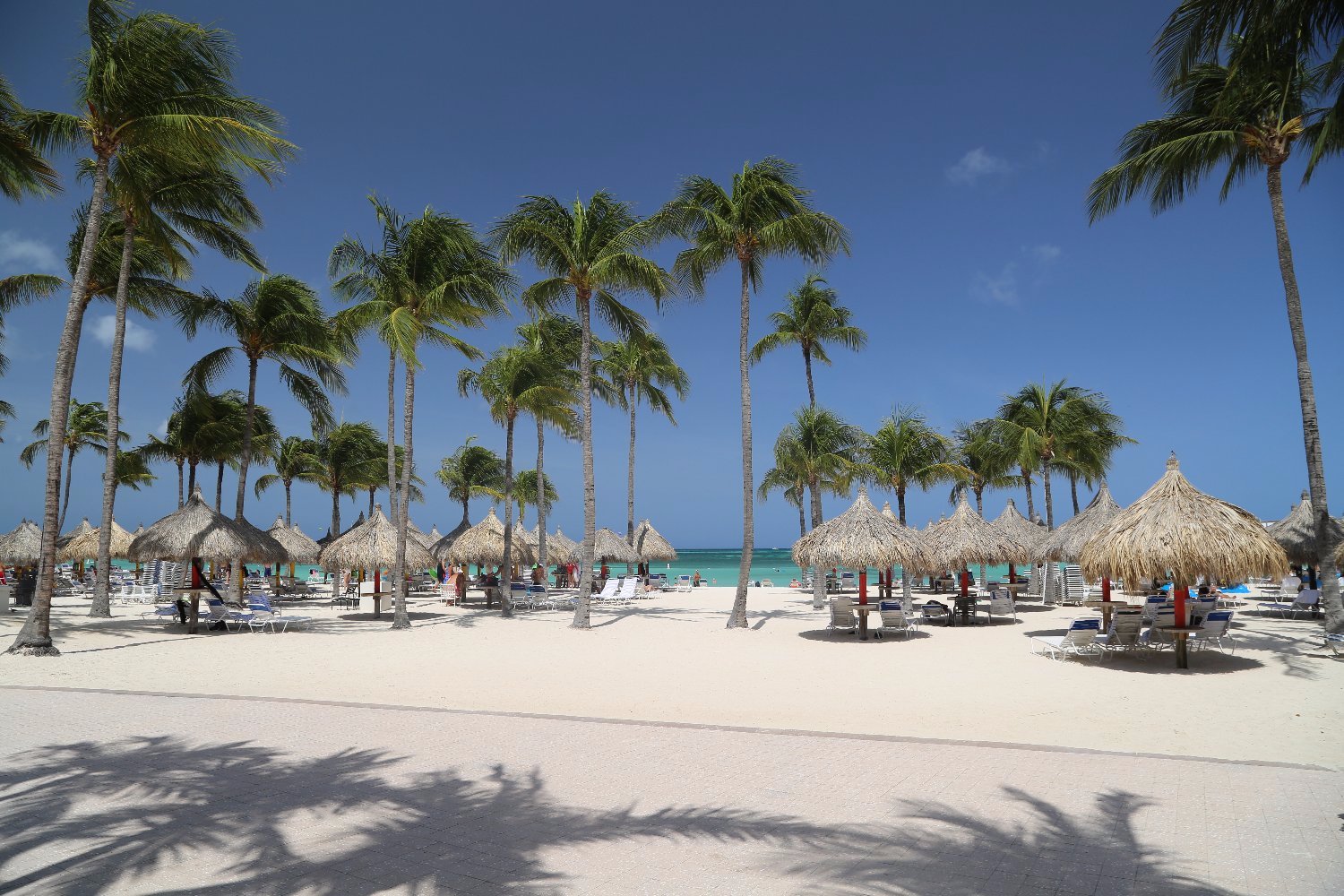
Oranjestad, the capital, stretches along the western coast beside a deep natural harbour used by cargo vessels and cruise ships. Streets near Caya G. F. Betico Croes stay busy with jewelry shops, government offices, and open-air markets selling Dutch snacks, aloe products, and Caribbean souvenirs. South of the capital, Palm Beach and Eagle Beach attract most of the resort development because the water stays calmer on this side of the island.
Aruba sits outside the main hurricane belt, which gives it a more stable climate pattern than several neighboring islands. Temperatures are consistently warm through most of the year, though the dry conditions become noticeable away from the beaches. Dust occasionally blows across from northern South America during windy periods.
Coastal Biodiversity and Topography of Barbados
Barbados has a very different landscape from Aruba. The island is greener because of higher rainfall, especially across the interior hills and eastern coastline. The Atlantic side near Bathsheba feels rougher and more exposed, with large rock formations sitting offshore beneath strong waves. Soup Bowl Beach attracts surfers throughout the year because of the consistent swell conditions coming across the Atlantic.
Bridgetown remains the commercial centre of the island, though coastal roads quickly lead to fishing villages and quieter beach areas. Along the south coast near Oistins, fishing boats return during the afternoon carrying flying fish, mahi-mahi, and tuna. The fish market becomes busiest toward sunset when locals queue beside cleaning stations, and vendors prepare seafood for the evening crowd.
Barbados also supports a wide range of marine life along its western coast. Sea turtles frequently appear near Carlisle Bay, where calm water and offshore wrecks attract divers and snorkelers. Inland sections of the island contain limestone caves, gullies, and dense vegetation supporting green monkeys and tropical birds.
Which destination fits your travel research?
These destinations attract travellers seeking warm weather, though each one functions very differently. Orlando revolves around major highways, entertainment districts, and suburban neighbourhoods spread across a wide metro area.
Meanwhile, Barbados moves at a slower pace through fishing villages, coastal roads, and long-established waterfront communities. Aruba’s dry northern coastline, shaped by trade winds and rocky terrain, feels completely different from the greener islands elsewhere in the Caribbean.
Across all these places, geography continues to influence the way people move, work, build communities, and experience daily life.


Leave a Reply