
For not having reservations pre-booked while traveling in Europe in mid summer, I had no issues booking hotels or hostels at the last minute. Before I arrived in Europe I made a list of hotels & hostels in every city I planned to stay the night in. Then I would then book various hotels while on the train or from downtime hanging around train stations or airports. Often times I would just show up in a city and find budget accommodation. Finding … [Read more...]


About Dave
http://www.davestravelcorner.com
Dave is an international travel writer and founder of Dave’s Travel Corner, a premier travel resource since 1996. He is well traveled (180 countries & territories); while on the road he enjoys the outdoors, backpacking, mountain climbing, meeting people, and experiencing other cultures.
Combining these interests with his expertise in technology, photography and writing, he shares his adventures on Dave’s Travel Corner and in select media outlets. Dave is most at home in Bangkok, Los Angeles, the Napa Valley or California’s Sierra Nevada mountains.
In 2006, he conceived the Napa Wine Project., a challenging endeavor to visit, taste with and extensively write about every winery in Napa Valley, California. He has now completed 1,200+ visits and written reviews of Napa wineries & producers.
His first book titled 'The Freeways of Los Angeles' was published in 2010.
He is a big proponent of experiential travel, valuing experiences far above "things".
Europe – Restaurants
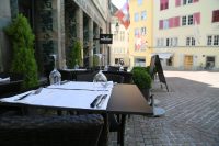
I ate at restaurants which ranged from luxurious to basic, to eating food from the street vendors. As with prices for other items and services, the prices of food at restaurants generally becomes more expensive moving from the south to the north. The exception to this was food in eastern Europe, which was a bit cheaper than the rest of Europe. Most restaurants charge for every little item. The only thing I don't think I was charged for was for … [Read more...]
Europe – Transportation
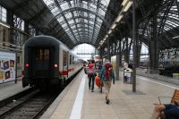
Finding one's way around a foreign city in the time of pre-Internet was a challenging situation at best taking significant time to avoid getting lost (which invariably happened anyway). One had printed maps that one had to determine their location on before being able to route a course to a desired destination. Not always easy without a digital blue dot to guide you. And road signs were often missing further causing complications. Later some … [Read more...]
Europe – The Locals

I think that whatever country you are traveling in you will meet the bad apples as well as the good oranges. On my first journey through Europe I met some very helpful people who went out of their way to give me advice, show me certain areas, or give me help. Then I met some overly stressed people who all they had to say was "stick it between your teeth". I could definitely tell a general difference in personality between different cultures … [Read more...]
Europe – Thieves

I put myself in a certain "stay away from people" - "trust absolutely no one" zone when I was in train stations or crowded areas. I would keep a good distance from other people and not let anyone get very close to me. My awareness of what was going on around me was extremely heightened to the point of paranoia when I had my backpack with me. If I stopped in a crowded area to look at a map or for some other reason I would always try to make sure … [Read more...]
Europe – Money

The Euro was introduced on January 1, 2002. 14 billion Euro banknotes and 55 billion coins were initially introduced to more than 300 million people in 12 countries of the European Union. 12 countries who initially converted were: Austria, Belgium, Finland, France, Germany, Greece, Ireland, Italy, Luxembourg, Netherlands Spain and Portugal, & Monaco. For a list of the Euro conversion rates (for the participating countries old … [Read more...]
Europe – More Info

This is information that was not able to find a home in any of the other categories in this article. Bathrooms Drinking Fountains Travel Books ID Cards Internet Access Student Organizations Links Airlines Transportation Budget General Tours Bathrooms Just about all the public bathrooms in Europe have an access charge. Usually this runs from several cents to several dollars depending on the country … [Read more...]
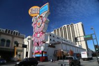
Reno, NV
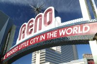
Long billed as the "biggest little city in the world" - today's population is over 250,000 and the city is somewhat spread out now but for a city of this size, it still perhaps feels bigger then the actual population. Reno is located in the high desert east of the Sierra Nevada Mountains north and slightly east of the great Lake Tahoe. Reno offers numerous non stop gambling opportunities 24 hours a day, 7 days a week. The city boasts a … [Read more...]
Reno, NV – Attractions
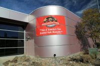
For a town of this size there are a fair number of attractions that are worth seeing. BaseCamp Reno is extremely unique; it is the world's tallest climbing wall (either indoor or outdoor) - in this case it is located outside on the east wall of the Whitney Peak Hotel (tall is a theme here - this hotel is appropriately named for the tallest mountain in the lower 48 states, Mt. Whitney - located in neighboring California). The climbing … [Read more...]
Reno, NV – Casinos
For those serious gamblers, for those who perhaps just dabble in gambling, and for those who don't gamble but want to see the action - Reno offers a pleasing diversity of casinos. And most of these casinos feature a large hotel, often in a separate building from the casino (sometimes connected by walkways). The majority of the casinos feature doors that must be pushed open - and once you push through a second set of doors, you are deposited into … [Read more...]
- « Previous Page
- 1
- …
- 273
- 274
- 275
- 276
- 277
- …
- 302
- Next Page »