
New Zealand pulls remote workers like nowhere else. The fibre broadband reaches further than you'd expect, the time zones work surprisingly well for Asian and Australian clients, and the scenery makes a 9am Zoom call feel almost bearable. But there's a catch. Most places you'll stay, from a Coromandel bach to a Queenstown Airbnb, were not designed with your spine in mind. Here's how to work through Aotearoa without arriving home with a sore … [Read more...]
Why Quezon Province Deserves a Bigger Place on Your Philippine Travel Bucket List
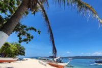
Some provinces do not need a hard sell. The moment you hear their name, you already know what kind of trip to expect. Quezon is different. It does not always lead the usual travel conversations the way Palawan, Cebu, or Siargao do, but that is exactly part of its strength. Quezon feels broader than one headline destination. It is not boxed into one travel identity. Instead, it gives you a province that can shift depending on what kind of … [Read more...]
How Electric Bikes Are Changing Adventure Travel
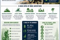
Adventure travel has changed dramatically over the last decade, and I have had the privilege of witnessing that transformation firsthand. As someone who has spent more than 10 years riding traditional bicycles and electric bikes across trails, mountain passes, coastal routes, and remote countryside roads, I can confidently say that electric bikes have reshaped what is possible for modern explorers. When electric bikes first entered the market, … [Read more...]
Moving Across Europe: Slowing Down and Starting Over in Portugal

A few months ago, my wife and I made a decision that completely changed our routine. After years of working traditional jobs with fixed schedules, we realized we wanted something different — more flexibility, more freedom, and the chance to build something for ourselves instead of always working for someone else. At the time, we were living in Belgium. While we enjoyed many things about life there, we also knew that trying to build a fully … [Read more...]
Tuscany Above the Clouds: A Guide to the Glacial Lakes and Ridges of the Northern Apennines
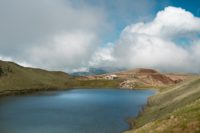
The wind hit the ridge hard enough that I leaned forward to keep my balance. Ahead of me, a narrow path followed the crest of the mountain like a thread pulled tight between two regions of Italy. On one side lay Tuscany. On the other, Emilia-Romagna. As the clouds shifted, a deep blue circle suddenly appeared below the ridge: Lago Scaffaiolo. At that moment it was hard to believe I was still in Tuscany. Most travelers imagine Tuscany as … [Read more...]
Malta Beyond the Postcard: Why This Tiny Island Deserves a Full Week

Malta is a small island but it has probably the highest density of things to see and do per square kilometre of anywhere I've been. I know that sounds like a brochure. It's not. You can drive across the main island in about 45 minutes. Most visitors give it a day or two, usually on a cruise ship stop — they walk around Valletta, take a photo of the harbour, and leave, which means they miss almost everything. Give Malta a week and you'll see what … [Read more...]
Majestic Siargao

The morning sun pierces through palm fronds as I stand at the edge of Cloud 9, Siargao's legendary surf break. The wooden boardwalk stretches before me like a runway to paradise, leading to the three-story viewing deck where photographers and tourists gather to witness surfers dance with the waves. The Pacific Ocean swells roll in with clockwork precision, each one transforming into perfect barrels that have made this tiny Philippine island a … [Read more...]
Apayao: Whispers of the Northern Frontier
The morning fog clung to the emerald mountains like a lover reluctant to leave. Our jeepney lurched forward on the winding road, and I steadied myself against the metal frame, my knuckles white with anticipation. The province of Apayao had long been a blank space on my mental map of the Philippines—a remote northern frontier that even many Filipinos know little about. This obscurity is precisely what drew me here, to the northernmost reaches of … [Read more...]
Chasing the Sea of Clouds in Tanay, Rizal: A Dreamy Escape Near Manila
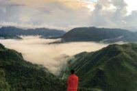
There is something magical about standing above a mountain ridge while a thick blanket of clouds rolls below your feet. It feels surreal, almost like the earth has disappeared and you are floating in the sky. That is exactly why the sea of clouds in Tanay, Rizal continues to attract hikers, campers, photographers, and weekend travelers looking for a refreshing escape from Metro Manila. Tanay has long been one of the most accessible adventure … [Read more...]
The One Thing That Can Ruin Your RV Road Trip (And How to Avoid It)
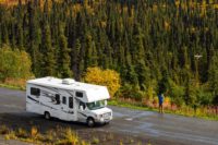
Nowadays, with what seems like endless workdays and everyday life stress, the one thing most people look forward to is their holiday and a new adventure. This is something we like to plan carefully; we consider what we’ll pack, where we’ll go, and what we’ll do and see. So, just imagine, after months of planning your RV road trip, you've mapped routes, booked campsites, and coordinated schedules. But suddenly, you’re stranded on a side of the … [Read more...]
- 1
- 2
- 3
- …
- 208
- Next Page »