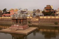
Hai! My name is Vijay and I live in Chennai. Chennai, though a very pleasant city in many other ways, gets intolerably hot in summer. This year, Chennai recorded the second highest temperature in two years! We were melting in our clothes. This is why, we shouted with joy when my father told us he was taking to Kodaikanal (a hill station) for a leisurely summer vacation. Our father booked the tickets through the Internet, for our railway … [Read more...]
A Glimpse of Kyrgyzstan

Kyrgyzstan is the quintessentially remote Central Asian land and arguably the worlds least known country. It is situated in the southeastern part of Central Asia bordered by Kazakhstan to the north, China to the east, China and Tadjikistan to the south, and Uzbekistan to the west. It is about 900 km long from east to west and 425 km from south to north. The area of the country (198.5 thousand sq. km) is comparable with such countries as … [Read more...]
Annapurna Circuit
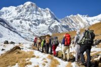
I'd always fancied myself as a bit of an outdoors-type, and what better way to prove it than a trek through the Himalayas. "Why would I want to walk for that long?" said a startled friend when I asked if he wanted to come along. Obviously he hadn't pictured it in his mind like I had. There it was; snow-capped peaks looming over pine-forests, twinkling stars dancing across the dark Northern skies, Tibetan prayer flags fluttering in the wind, … [Read more...]
The Flood, The Tsunami Dec 26

If there is a Paradise on earth it must be here. We repeatedly confirm each other in that statement, several times a day. Mai's Quiet Zone is the name of the little resort where we live, here in the Northern part of Khao Lak. It is not a misnomer. With her husband, the Thai woman Mai has created an area where everything breathes idyllic peace. On the beach are some practical little red brick and bamboo bungalows. Two storey bungalows encircle … [Read more...]
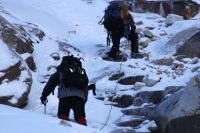
Huaraz, Peru – Ishinca Trek
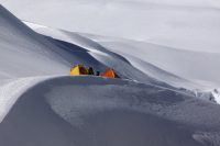
During several attempts to climb Ishinca & Toclaraju Dave used Enrique Expeditions, based in Huaraz - as well as a number of guides who for the most part spoke primarily Spanish with only a few words of English. Spanish was the primary language we used when climbing. Guides Francisco and Julio have both been guiding in the mountains for many years - each man has significant experience climbing. Julio has reached the summit of Huascaran (the … [Read more...]
Huaraz, Peru – Trekking Companies
Numerous tour guides in Huaraz offer day trips - most are congregated around or just off of the main street near downtown. For day trips, typically you will be picked up at your hotel between 6 and 8am in the morning and dropped off at your hotel between 6 and 7pm in the evening. Travelers certainly can arrange independent travel for day trip activities by by hiring a private taxi or taking a mini bus called a "collectivo". For longer treks or … [Read more...]
Huaraz, Peru – More Info

Banks Several local and national banks are located in Huaraz as well as 24/7 ATM's - these are all located close to the Plaza del Armas and downtown area. We've used a variety of ATM cards during our trips to Huaraz and never had any problems with the ATM's in town. Money Many of the trekking agencies only accept cash. All convenience stores only accept cash. Pharmacies and some restaurants accept major credit cards. As in other parts of … [Read more...]
Death Valley, CA – The Heat

The heat here is simply awesome. Death Valley on average is the hottest place in the world. Its that simple - this valley can "cook". Names such as Stovepipe Wells, Furnace Creek, Devils Golf Course and Hells Gate are a dead giveaway as to the types of temperatures this valley experiences. Historically July is the hottest month of the year although late June can also see extreme temperatures. Seasons are turned around compared to typical … [Read more...]
Death Valley, CA – Accomodation

CAMPING Death Valley National Park features a variety of campgrounds, some quite large like the 1000+ Sunset campground near Furnace creek (only open in the winter months), to just a few camp spaces. Many campgrounds close for the summer season - approximately mid April through mid October. For the campgrounds that do stay open in the summer months, often the prices will be cheaper. We have often found campgrounds closed in the park due to … [Read more...]
New Zealand, South Island – Mt. Cook
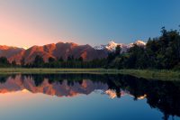
Mt Cook is by far one of the most impressive highlights of the South Island and New Zealand in general. A prominent peak with its jagged edges, angry looking glaciers and height, it towers above the nearby mountains. The beauty of this area is that you can experience to a small extent, what the Himalayas look like from only an elevation of about 500 meters. On clear days the panoramic vistas are absolutely stunning. Note that Mt. Cook is … [Read more...]
- « Previous Page
- 1
- …
- 71
- 72
- 73
- 74
- 75
- …
- 84
- Next Page »